NASA - EOS Aqua Mission logo.
April 7, 2017
Ernie (was 15S - Southern Indian Ocean)
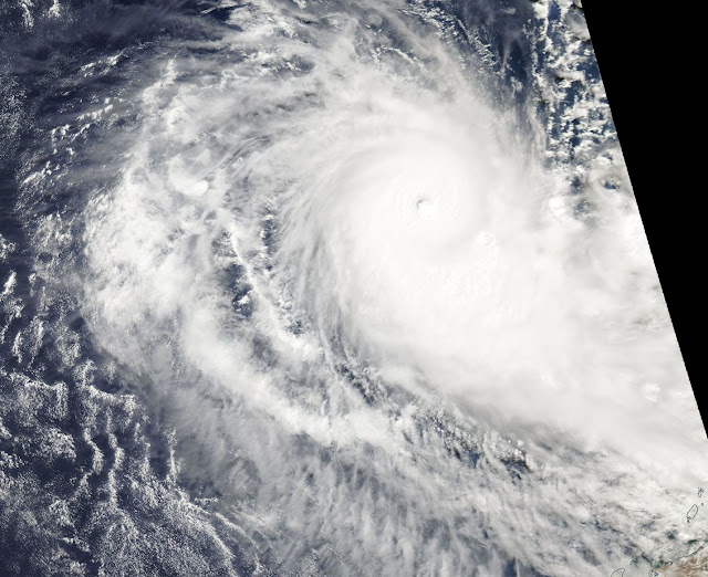
The storm formerly known as tropical cyclone 15S, now called Tropical Cyclone Ernie continued to strengthen as NASA's Aqua satellite captured a visible image that showed the storm developed an eye.
Image above: NASA's Aqua satellite passed over Ernie on April 7 at 0645 UTC (2:45 a.m. EST) and saw an eye had formed as the storm strengthened into a hurricane. Thick bands of powerful thunderstorms surrounded the eye. Image Credit: NASA.
NASA's Aqua satellite passed over Ernie on April 7 at 0645 UTC (2:45 a.m. EST) and the Moderate Resolution Imaging Spectroradiometer or MODIS instrument took a visible image of the storm. The image showed an eye had formed as the storm strengthened into a hurricane. Thick bands of powerful thunderstorms surrounded the eye.
At 0900 UTC (5 a.m. EST) on April 7, Ernie's maximum sustained winds were near 95 knots (109 mph/175 kph). It was away from land areas, about 467 nautical miles (538 miles/865.5 km) north-northwest of Learmonth, Western Australia. It was centered near 15.4 degrees south latitude and 110.3 degrees east longitude. Ernie is moving to the south at 5 knots (5.7 mph/9.2 kph).
The Joint Typhoon Warning Center expects Ernie to move in a south-southwesterly direction and weaken.
Apr. 06, 2017 - A NASA Infrared Look at the Southern Indian Ocean's 15th Tropical Cyclone
NASA's Aqua satellite passed over Tropical Cyclone 15S in the Southern Indian Ocean and obtained temperature data on the cloud tops, enabling scientists to see where the strongest part of the storm was located.
Image above: This NASA infrared image of Tropical Cyclone 15S on April 6 at 0105 UTC (April 5 at 9:05 p.m. EST) showed strongest storms with cloud top temperatures of thunderstorms as cold (purple) as -63F/-53C. Image Credits: NASA JPL, Ed Olsen.
The Atmospheric Infrared Sounder or AIRS instrument aboard NASA's Aqua satellite looked at Tropical Cyclone 15S in infrared light. Infrared light provides scientists with temperature data and that's important when trying to understand how strong storms can be. The higher the cloud tops, the colder and the stronger the storms that make up a tropical cyclone.
NASA's Aqua satellite flew over Tropical Cyclone 15S on April 6 at 0605 UTC (2:05 a.m. EST). AIRS detected strongest storms around the center of circulation with cloud top temperatures as cold as minus 63 degrees Fahrenheit (minus 53 degrees Celsius). Storms with cloud top temperatures that cold have the capability to produce heavy rainfall.
The Joint Typhoon Warning Center or JTWC stated on April 6 at 0900 UTC (5 a.m. EST) newly formed Tropical Cyclone 15S had maximum sustained winds near 35 knots (40 mph/62 kph). 15S was centered near 13.5 degrees south latitude and 110.7 degrees east longitude, about 572 nautical miles (658 miles/1,059 km) north-northwest of Learmonth, Australia. 15S was moving to the south-southwest at 4 knots (4.6 mph/7.4 kph) away from Australia.
Artist's view of Aqua satellite. Image Credit: NASA
The JTWC noted "Upper level atmospheric analysis Indicates the system is in an area of strong westerly vertical wind shear. Additionally, a mid-latitude trough or elongated area of low pressure is causing subsidence along the southwestern quadrant (of the storm)." Subsidence means sinking air, and that prevents cloud formation as air has to rise in order to condense to form clouds and the thunderstorms that make up a tropical cyclone.
Tropical Cyclone 15S is moving along the northwestern edge of an elongated area of subtropical high pressure, which is located southeast of the storm. That means that 15S expected to continue tracking south-southwestward around that high pressure area, turning more to the west as the high pressure builds.
JWTC forecasts this system will be short-lived because vertical wind shear will increase in the direction the storm is heading. It is expected to dissipate in three days by April 9.
Aqua Satellite: https://www.nasa.gov/mission_pages/aqua/index.html
Images (mentioned), Text, Credits: NASA's Goddard Space Flight Center/Rob Gutro.
Greetings, Orbiter.ch


