
NASA & ESA - Cassini-Huygens Mission to Saturn & Titan patch.
March 24, 2016

Figure A
Each of these two montages shows four synthetic views of Titan created using data acquired by the visual and infrared mapping spectrometer (VIMS) on board NASA's Cassini spacecraft between 2004 and 2015. These views demonstrate some of the progress researchers have made in creating smooth-looking maps of Titan from the multitude of different VIMS observations made under a wide variety of lighting and viewing conditions.
Cassini has flown past Titan about once per month, on average, since 2004, in order to observe the giant moon and to take advantage of its gravity for shaping the spacecraft's trajectory. With each flyby, VIMS has a brief opportunity to add small pieces to the instrument's overall mapping coverage of Titan.
Producing a seamless global map of Titan is a challenging task, because observing conditions can vary greatly between each flyby. Among these variations are changes in the angle of the sun with respect to the surface and in the spacecraft's viewing direction. Such variations can make it even more difficult to remove the effects of scattering and absorption of light by Titan's thick, hazy atmosphere. These effects can also influence how bright different areas of the surface appear. Seasonal changes may also have played a role in changing the appearance of Titan's surface over the course of Cassini's long mission. These factors create a complex problem that researchers are still working to solve.
In each montage, the images from left to right present different views that demonstrate the broad spectral capability of the VIMS instrument. The upper row of images in each montage shows a particular region of interest; one features the 50-mile-wide (80-kilometer-wide) Sinlap impact crater, while the other focuses on the region surrounding the landing site for ESA's Huygens probe. The lower row of images features maps of the hemispheres in which these regions are located.
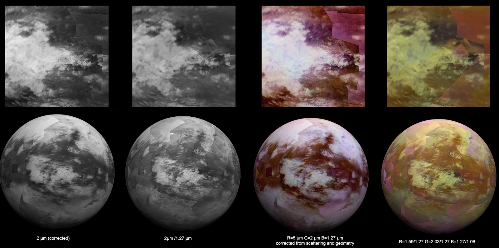
Figure B
The images at far left show the surface at 2 microns, a wavelength where the atmosphere is quite transparent to infrared light.
The views at the next position are spectral ratio images -- in which an image at one wavelength is divided by an image at another wavelength. This technique can be used to emphasize subtle spectral variations on the surface, some of which are related to differences in composition.
The third view is a color composite with light at 5 microns shown in red, 2 microns shown in green and 1.27 microns shown in blue. (All component images were corrected for atmospheric and photometric effects.)
The final (rightmost) views are color composites created using ratios that divide the brightness of the surface in one set (or band) of wavelengths by that of another set in order to produce the red, green and blue channels of a color composite image. Like spectral ratio images, these images may reveal differences in the nature of surface materials.
Cassini Spies Titan's Tallest Peaks

Image above: The trio of ridges on Titan known as Mithrim Montes is home to the hazy Saturnian moon's tallest peak. Image Credits: NASA/JPL-Caltech/ASI.
In a nod to extraterrestrial mountaineers of the future, scientists working on NASA's Cassini mission have identified the highest point on Saturn's largest moon, Titan.
Titan's tallest peak is 10,948 feet (3,337 meters) high and is found within a trio of mountainous ridges called the Mithrim Montes. The researchers found that all of Titan's highest peaks are about 10,000 feet (3,000 meters) in elevation. The study used images and other data from Cassini's radar instrument, which can peer through the obscuring smog of Titan's atmosphere to reveal the surface in detail.
"It's not only the highest point we've found so far on Titan, but we think it's the highest point we're likely to find," said Stephen Wall, deputy lead of the Cassini radar team at NASA's Jet Propulsion Laboratory in Pasadena, California.
The results, which use data collected by Cassini's radar instrument, are being presented today at the 47th annual Lunar and Planetary Science Conference at The Woodlands, Texas.
Most of Titan's tallest mountains appear to be close to the equator. The researchers identified other peaks of similar height within the Mithrim Montes, as well as in the rugged region known as Xanadu, and in collections of more isolated peaks called "ridge belts" located near the landing site of ESA's Huygens probe.

Cassini spacecraft Titan flyby
The investigation was originally motivated by a search for active zones within Titan's crust -- places where dynamic forces have shaped the landscape, perhaps in the relatively recent past.
"As explorers, we're motivated to find the highest or deepest places, partly because it's exciting. But Titan's extremes also tell us important things about forces affecting its evolution," said Jani Radebaugh, a Cassini radar team associate at Brigham Young University in Provo, Utah, who led the research.
Mountains and cliffs on Earth usually are found in locations where forces have shoved the surface upward from underneath. Forces of erosion, including wind, rain and runoff, slowly wear them down over time. The Himalaya and Andes Mountains are examples of places where interior forces are at work today. The Appalachian Mountains represent much more ancient activity that produced similarly gigantic peaks long ago, which have since eroded.
Cassini has found that Titan also has rain and rivers that erode its landscape. According to Radebaugh, the process probably proceeds much more slowly on Titan than on Earth because, at 10 times Earth's distance from the sun, there is less energy to power erosive processes in the moon's atmosphere.

Image above: This map of Saturn's moon Titan identifies the locations of mountains that have been named by the International Astronomical Union. Image Credits: NASA/JPL-Caltech/University of Arizona/USGS.
Titan's icy crust sits atop a deep ocean of liquid water that probably acts much like Earth's upper mantle -- the layer of hot, high-pressure rock below the crust that can slowly flow and deform over time. Once a period of mountain-building ends, these fluid layers (Earth's upper mantle and Titan's liquid ocean) allow the crust to relax, like a person settling into a waterbed. Also, at great depth, the water-ice bedrock of Titan is softer than rock on Earth. Because of these characteristics, scientists didn't expect mountains on Titan would tower quite as high as those on Earth, which can rise to more than 5 miles (nearly 9 kilometers) tall.
The fact that Titan has significant mountains at all suggests that some active tectonic forces could be affecting the surface, for example, related to Titan's rotation, tidal forces from Saturn or cooling of the crust. The next step for the researchers will be trying to figure out what could produce such tall peaks on an icy ocean world.
"There is lot of value in examining the topography of Titan in a broad, global sense, since it tells us about forces acting on the surface from below as well as above," said Radebaugh.
The Cassini mission is a cooperative project of NASA, ESA (the European Space Agency) and the Italian Space Agency. The Jet Propulsion Laboratory, a division of the California Institute of Technology in Pasadena, manages the mission for NASA's Science Mission Directorate, Washington. The Cassini orbiter and its two onboard cameras were designed, developed and assembled at JPL. The visual and infrared mapping spectrometer team is based at the University of Arizona.
For more information about the Cassini-Huygens mission http://saturn.jpl.nasa.gov/home/index.cfm. The visual and infrared mapping spectrometer team homepage is at http://www.vims.lpl.arizona.edu and ESA's website: http://www.esa.int/Our_Activities/Space_Science/Cassini-Huygens
Images, Text, Credits: NASA/Martin Perez/JPL/Preston Dyches.
Greetings, Orbiter.ch